


MapCircle
وصف لـMapCircle
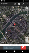
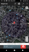
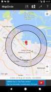
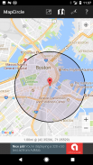
MapCircle is a simple app that allows you to visualize distances by displaying a map with an overlaid circle or donut of a specified radius.
The circle view is useful when you want to see everything that's less than some specified distance from some location.
The donut view is useful when you know that something is "a mile away" (or some other distance), but aren't sure exactly WHERE it is & want to try and guess its likely location. The donut itself represents the region of uncertainty and margin of error.
Features:
* Distance in Miles and Kilometers
* Easily toggle between regular and hybrid map views (hybrid is aerial/satellite image with overlaid map)
* Two visualization types: circle and donut
MapCircle هو التطبيق بسيط الذي يسمح لك لتصور المسافات عن طريق عرض خريطة مع دائرة مضافين أو دونات من دائرة نصف قطرها محدد.
وجهة نظر دائرة مفيد عندما كنت تريد أن ترى كل ما هو أقل من مسافة معينة من بعض الموقع.
وجهة نظر دونات مفيد عندما تعلم ان هناك شيئا "ميل" (أو بعض المسافة غيرها)، ولكن لم تكن متأكدا من مكانه بالضبط وتريد أن تجرب وتخمين موقعها المحتمل. دونات نفسها تمثل المنطقة من عدم اليقين وهامش الخطأ.
ميزات:
* المسافة في الأميال والكيلومترات
* تبديل بسهولة بين وجهات النظر الخريطة العادية والمختلطة (الهجين الجوي / صورة الأقمار الصناعية مع خريطة مضافين)
* هناك نوعان التصور: دائرة ودونات
MapCircle - إصدار 1.05
(20-01-2020)MapCircle - معلومات APK
نُسخة APK: 1.05الحزمة: software.pantherkitty.mapcircleآخر إصدار من MapCircle


تطبيقات من الفئة نفسها


